Log in
Todos os recursos
Creează un design
2.086 Imagini gratuite pentru Site Web
internet
albastru
telefon
acțiune
tehnologie
căutare
chat
afacere
reţea
piaţă
site web
gol
site web
inimă
site web
vedere
site web
ceas
site web
mut
site web
telefon
site web
acțiune
site web
stea
tehnologie
trafic
site web
rundă
site web
pătrat
site web
calendar
site web
chat
site web
tare
site web
poștă
site web
repeta
site web
căutare
fereastra
site web
geologie
nor
albastru
afacere
electrocasnice
cumpărături
pictogramă
simbol
pictogramă
simbol
iahting
1101 - 1200 din 2.086
Pagina următoare
/ 21


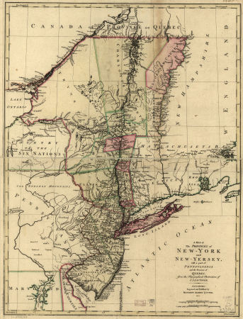
![[Ten maps and views of the battlefields of the American Revolutionary War in the states of Pennsylvania and New York], 1777](https://cdn.creazilla.com/illustrations/10001550825/ten-maps-and-views-of-the-battlefields-of-the-american-revolutionary-war-in-the-states-of-pennsylvania-and-new-york-1777-md.jpg)

![[Map of the defeat of the Confederate ship Alabama by the U.S. steamer Kearsarge on June 19, 1864, off Cherbourg, France].](https://cdn.creazilla.com/illustrations/10001534884/map-of-the-defeat-of-the-confederate-ship-alabama-by-the-us-steamer-kearsarge-on-june-19-1864-off-cherbourg-france-md.jpg)
![Winter quarters built by the rebels, now occupied by the 67th reg. P.V., 3d Brig., 3d Div., 3d Corps, A.P., [n]ear Brandy Station, Va., Louis N. Rosenthal, 1863](https://cdn.creazilla.com/illustrations/10001053331/winter-quarters-built-by-the-rebels-now-occupied-by-the-67th-reg-p-v-3d-brig-3d-div-3d-corps-a-p-n-ear-brandy-station-va-louis-n-rosenthal-1863-sm.jpg)


![[Terrestrial globe gores]., 1615](https://cdn.creazilla.com/illustrations/10000787689/terrestrial-globe-gores-1615-md.jpg)

![[Ten maps and views of the battlefields of the American Revolutionary War in the states of Pennsylvania and New York], 1777](https://cdn.creazilla.com/illustrations/10001455242/ten-maps-and-views-of-the-battlefields-of-the-american-revolutionary-war-in-the-states-of-pennsylvania-and-new-york-1777-md.jpg)
![[Ten maps and views of the battlefields of the American Revolutionary War in the states of Pennsylvania and New York], 1777](https://cdn.creazilla.com/illustrations/10000484458/ten-maps-and-views-of-the-battlefields-of-the-american-revolutionary-war-in-the-states-of-pennsylvania-and-new-york-1777-md.jpg)


![[Ten maps and views of the battlefields of the American Revolutionary War in the states of Pennsylvania and New York], 1777](https://cdn.creazilla.com/illustrations/10001122410/ten-maps-and-views-of-the-battlefields-of-the-american-revolutionary-war-in-the-states-of-pennsylvania-and-new-york-1777-sm.jpg)


![[Ten maps and views of the battlefields of the American Revolutionary War in the states of Pennsylvania and New York], 1777](https://cdn.creazilla.com/illustrations/10000597684/ten-maps-and-views-of-the-battlefields-of-the-american-revolutionary-war-in-the-states-of-pennsylvania-and-new-york-1777-md.jpg)
![[Ten maps and views of the battlefields of the American Revolutionary War in the states of Pennsylvania and New York], 1777](https://cdn.creazilla.com/illustrations/10001450663/ten-maps-and-views-of-the-battlefields-of-the-american-revolutionary-war-in-the-states-of-pennsylvania-and-new-york-1777-md.jpg)
![[Ten maps and views of the battlefields of the American Revolutionary War in the states of Pennsylvania and New York], 1777](https://cdn.creazilla.com/illustrations/10000887733/ten-maps-and-views-of-the-battlefields-of-the-american-revolutionary-war-in-the-states-of-pennsylvania-and-new-york-1777-md.jpg)
![[Ten maps and views of the battlefields of the American Revolutionary War in the states of Pennsylvania and New York], 1777](https://cdn.creazilla.com/illustrations/10000506393/ten-maps-and-views-of-the-battlefields-of-the-american-revolutionary-war-in-the-states-of-pennsylvania-and-new-york-1777-md.jpg)